Race Route
Maps of full, half marathon and 5 mile trail run for 2024 - Scroll down for Aid Station Info.
Full Marathon


.png)
Half Marathon


5 Mile Trial Run

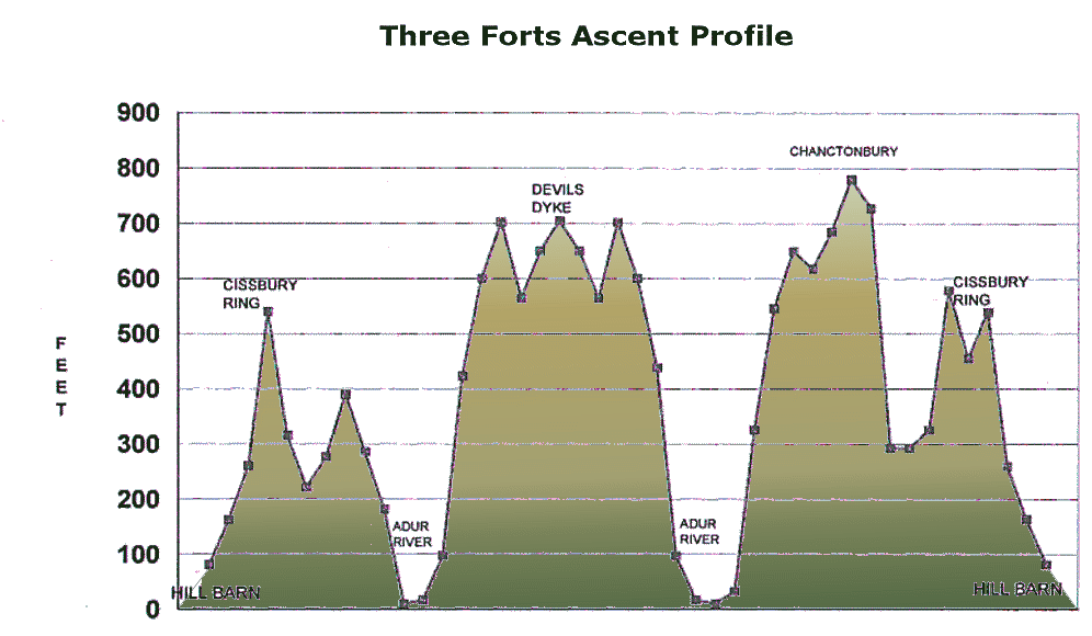
Ascent Profile
Aid Stations
Progress of runners will be monitored by radio (South Sussex Raynet) and Medical Aid will be in attendance at key locations on the course. If it is necessary to drop out of the race, please do so at an Aid Station and ensure that the Marshals are told. Limited rescue facilities exist to get any runners back to the start. All runners are expected to finish the course in a MAXIMUM of six hours
| Aid Station | Grid Ref. | Distance to | Half Marathon | Distance to | Marathon | ||||
| Total | Total | ||||||||
| Start | Hill Barn | TQ142055 | 0 | 0 | 0 | 0 | |||
| 1 | Cissbury Ring | TQ140085 | 2.2 | 2.2 | 2.2 | 2.2 | |||
| 2 | Beggars Bush | TQ162080 | N/A | N/A | 1.5 | 3.7 | |||
| 3 | Adur River | TQ107095 | N/A | N/A | 3.2 | 6.9 | |||
| 4 | Truleigh Hill | TQ220105 | N/A | N/A | 1.5 | 8.4 | |||
| 5 | Devil's Dyke | TQ257107 | N/A | N/A | 2.7 | 11.1 | |||
| 6 | Truleigh Hill | TQ220105 | N/A | N/A | 2.7 | 13.8 | |||
| 7 | Adur River | TQ107095 | N/A | N/A | 1.5 | 15.3 | |||
| 8 | Steyning Bowl | TQ162097 | 2 | 4.6 | 3 | 18.3 | |||
| 9 | Chanctonbury Ring | TQ137120 | 1.7 | 6.9 | 1.7 | 20 | |||
| 10 | New Barn Farm | TQ128099 | 2.5 | 9.4 | 2.5 | 22.5 | |||
| 11 | Cissbury Ring | TQ140085 | 2.5 | 11.9 | 2.5 | 25 | |||
| Finish | Hill Barn | TQ142055 | 2.2 | 13.1 | 2.2 | 27.2 | |||
Aid Stations are spaced along the route to provide refreshment and support to entrants.